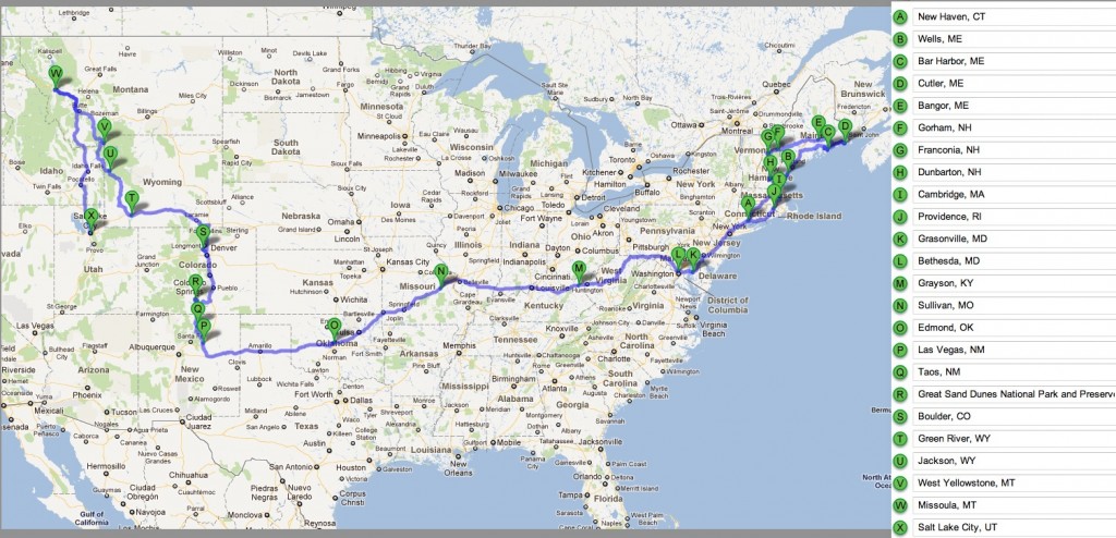
I have received puzzled questions from friends and family alike, wondering where we are, where we have been, and are we really moving to Colorado? So, here’s a little recap of our cross-country meandering, to date. In the form of a map. (You might have to click two or three times to get a legible version).
I hadn’t actually mapped the entire trip until now, so it’s interesting to see! Here’s a few statistics we’ve amassed so far:
- Total miles in the car: 5,232
- Number of towns we’ve called home: 24
- States traversed: (21) CT, MA, ME, NH, RI, NY, NJ, MD, VA, WV, KY, IN, IL, MO, OK, TX, NM, CO, WY, MT, ID, UT
- States never seen before: Maggie: 6 (KY, IN, IL, MO, NM, ID), Louis: 4 (ME, WY, MT, ID)
- Best meal: El Diavolo at Pizzeria Locale, Boulder, CO. According to Louis this is definitely some authentic Italian pizza. According to me, just the best freaking pizza I’ve had in my life. Sorry, New Haven! The ingredients are all super fresh, and the neapolitan-style crust is delicate and fluffy on top, with a perfect crisp on the bottom. I didn’t even realize until now that pizza does not have to be heavy and greasy and vaguely gross! Yes, a ringing endorsement, I know.
- Worst meal: A “chicken” sandwich at a cafeteria in Yellowstone National Park that must have been pumped full of water and then frozen and thawed about seven times.
- Hardest hike: Cadillac and Dorr Mountains in Acadia National Park. I downplayed the amount of pain I was in in the original post, because at the time I was worried that plantar fasciitis was going to ruin the whole trip. It hasn’t — at all! yay! — so I can now say that I really, really wished I had crutches in the final mile.
- Coldest night: Sand Dunes National Park, 20F
- Number of car fuses blown: 3
- Number of bike flat tires: 2
- Time between leaving New Haven, CT and move-in day in Boulder, CO: 114 days (that’s 16 weeks, or about 3.8 months!) But yes, we are in fact moving to Boulder, and we even have an apartment lined up.
- Total elevation gain in the car: 148,403 feet (that’s 28.11 miles!)
If you’re curious as to how I came up with this number, I downloaded a KML file from a saved route on Google Maps, then opened this file in Google Earth. If you left click on the route in Google Earth, there is an option to “Display Elevation Profile” which also calculates cumulative elevation gain and loss.
- Total elevation loss in the car: 144,197 feet (27.31 miles).
Note that this number is probably only accurate to within about 10% (or perhaps worse?) because GPS elevation data is not perfectly accurate. Some of the data comes from NASA’s Shuttle Radar Topography Mission which has a 30-meter horizontal resolution in the U.S.A. According to this (pdf) the measurements in the National Elevation Dataset have an elevation root-mean-squared error of 2.44 meters (8 feet). This could mean that cumulative elevation gain along a route is overestimated. (You could smooth the jaggedness of the data, but then you might underestimate the cumulative elevation gain — sometimes a road really does have lots of bumps — so it’s not clear what the optimal strategy is).
- Number of hikes: 18 blogged. I also walked about 4 miles a day while in Boulder (10 days) because I was lazy and didn’t get my bike out, and our hotel was out of town a bit. Then there were scattered other hikes that didn’t make it into the blog (see laziness, above). So let’s just say 30.
- Number of bike rides: 7 (also an underestimate, but sadly not by much — with my bike strategically and carefully stored in several pieces in a very packed car, I usually didn’t bother to take the bike out unless we were in one place for over a week. I’m still so glad I brought it along!)
- Number of books read: Louis: 6, Maggie: 4
- Number of pictures taken: 1663

